With transient killer whales in the area and the whereabouts of J and L pods (and their many newborns!) unknown, we were concerned to hear that active sonar was utilized late in the morning on Wednesday, January 13, in Haro Strait — critical habitat for species in both Canada and the U.S. At the same time, military training activities were planned or taking place on both sides of the border. This is what it sounded like underwater along the western shoreline of San Juan Island —
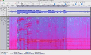
Complex sonar sequence recorded in Haro Strait on 1/13/2016 via the Orcasound hydrophone (~5km north of Lime Kiln State Park).
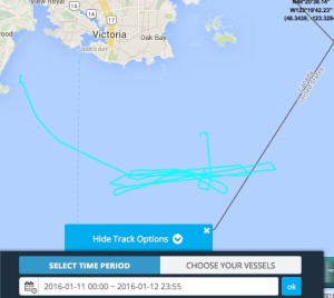
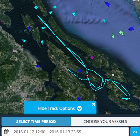
When the sonar was heard and recorded by members of the Salish Sea Hydrophone Network the Canadian Naval vessel HMCS Ottawa was observed (via AIS) transiting Haro Strait in U.S. waters about 10-20 km north of the hydrophones.
This juxtaposition led us to initially assert that the Ottawa — a Halifax class frigate which carries active sonar — was the source of the sonar pings, reinforced by the activation of the test range (area Whiskey Golf off Nanaimo) on 1/12 and 1/14. However, a proactive call to Beam Reach on 1/14/16 from Danielle Smith, Environmental Officer for Canadian Forces Base Esquimalt, suggested that the Ottawa was not the source. Specifically, she stated that active sonar use was not in their plan when they last departed. She also said she spoke directly with the Ottawa’s Commanding Officer who confirmed with the crew that the transducers were not lowered, and that therefore there was no way their SQS-510 (medium frequency search sonar system) could have transmitted (e.g. sometimes calibrations underway go unreported). Finally, she communicated that their senior sonar techs were confident that the recorded frequencies were not consistent with the Ottawa’s 510 system. When asked, she confirmed that the sonar system had not been upgraded since it was last recorded during the 2012 vent in which the Ottawa disturbed and possibly damaged the endangered Southern Resident Killer whales.
Other sources of information also suggest that the U.S. Navy may have been the source of the sonar pings.
Furthermore, comparison of the times of the recorded sonar pings and available AIS tracks suggests that the sonar was recorded when the Ottawa was located between the north Henry Island and Turn Point at the northwest tip of Stuart Island. If the source was the Ottawa, why would it have utilized sonar only while within U.S. waters (about 1-2 km east of the International Boundary). During this period, the Ottawa was about 8-16 km north of the recording hydrophones. Pending computation of the calibrated received levels, the qualitative intensity of the received pings suggests that the source was closer than the Ottawa’s AIS positions allow.
Smith’s statements and these observations raise a key question:Â were U.S. vessels in the area emitting these sounds that are similar to those emitted by the US destroyer Shoup in 2003?
Visual observations demonstrate that U.S. Naval ships were active on 1/13/20016. At least one U.S. Naval ship, possibly a frigate, was seen departing Everett around mid-day by Orca Network. Slightly earlier, between 10:30 and 11:30 a.m Howard Garrett of Orca Network saw two Navy ships transiting northward up Admiralty Inlet about 15 min. apart. The first one looked like the Shoup, complete with the cannon on the bow; the second looked more like a supply ship.
(1/17/16 update: A citizen scientist observed two Naval ships southbound in Haro Strait between Turn Point and D’Arcy Island at around 10:45 a.m. — roughly coincident with the sonar heard on the nearby Orcasound hydrophone. 1/19/16: Navy Region Northwest has confirmed a U.S. Naval ship was “in the area…”)
Update 1/22/16: Navy Region Northwest Deputy, Public Affairs, Sheila Murray stated in an email to Beam Reach,
“A U.S. Navy DDG was transiting within the Strait of Juan de Fuca on the U.S. side of the waterway (not in or near the Haro Strait). The DDG confirmed sonar use consistent with recordings on the Beam Reach Facebook page for a brief period of time, approximately 10 min. There were trained lookouts stationed during this event. No marine mammals were sighted during the activity and no marine mammal vocalizations were detected by passive acoustic monitoring. The ship was briefly operating its sonar system for a readiness evaluation in order for the ship to deploy in the near future.”
It is not clear whether the DDG (Guided Missile Destroyer) was one of the Everett-based ships — the Shoup or Momsen — or if it was based elsewhere (e.g. one of the 15 destroyers stationed in San Diego). [Update 1/25/2016: Navy Region Northwest has, however, re-directed a question from Beam Reach regarding the procedures followed by the ship to the Third Fleet (based in San Diego) suggesting that the DDG may have been based in California.]
Update 2/4/16: Lt. Julianne Holland, Deputy Public Affairs Officer Commander, U.S. Third Fleet responded to a question posed by Beam Reach,
Below is the response to your question: Did the DDG obtain permission from the Commander of the Pacific Fleet in advance of this use of MFAS in Greater Puget Sound?
The Navy did not anticipate this use within the Strait of Juan de Fuca. The use of sonar was required for a deployment exercise that was not able to be conducted outside of the Strait due to sea state conditions. The Navy vessel followed the process to check on the requirements for this type of use in this location, but a technical error occurred which resulted in the unit not being made aware of the requirement to request permission. The exercise was very brief in duration, lasting less than 10 minutes, and the Navy has taken steps to correct the procedures to ensure this doesn’t occur again at this, or any other, location. The Navy also reviewed historical records to confirm this event has not occurred before and was a one-time occurrence within the Puget Sound/Strait of Juan de Fuca. The Navy reported the incident to NMFS and NMFS determined that no modifications to the Navy’s authorization are needed at this time.
Below is a chronology of events, wildlife sightings, and acoustic analysis that we hope will help document the event, including the source of the sonar and any impacts on marine life of the Salish Sea.
Key events (local time, PST):
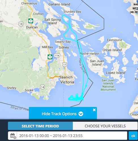
Tue 1/12/16 14:30 PST: Ottawa in search pattern all afternoon and night (1-7 knots, east of Constance Bank)
Wed 1/13/16 09:00 PST: Ottawa moves north into Haro Strait
Wed 1/13/16 10:00 PST: Ottawa enters U.S. waters between False Bay and Discovery Island, proceeds north
Wed 1/13/16 10:45 PST: Intense sonar pings recorded on the Orcasound hydrophone (originating from a U.S. destroyer in the Strait of Juan de Fuca)
Wed 1/13/16 11:00 PST: Ottawa leaves U.S. waters near Turn Point, Stuart Island
Detailed Chronology (public Google spreadsheet):
Acoustic recordings and analysis
8 minute recordings from Lime Kiln and Orcasound
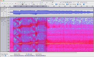
Jeanne Hyde provided 2 recordings — each about 8 minutes long — of a sequence of sonar pings. The first is from the Lime Kiln lighthouse hydrophone (but we believe there is some drift in the time base, so this recording should not be used to assess event timing, like sonar initiation, duration, or ping intervals) —
Lime Kiln 8-minute recording (10:41)
Spectrogram of 8-minute recording from the Lime Kiln hydrophone.
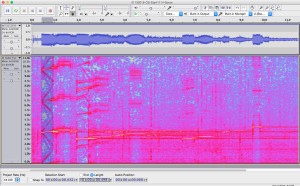
— the second is from the Orcasound hydrophone (about 5 km north of Lime Kiln) —
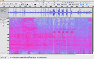
Orcasound 8-minute recording (10:55)
Spectrogram of 8-minute recording from the Orcasound hydrophone.
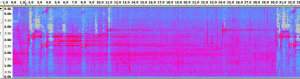
Assuming that drift in the Lime Kiln recording has corrupted its time base, we use the Orcasound to establish timing of the event. Overall, the event consists of a pattern of broadband pulses and ~30-second sequences of frequency modulated (FM) slide and narrowband continuous wave (CW) pulses. The ~9-minute pattern was: two simple, ascending FM+CW sequences, 52 broadband pulses (2.5-3.0 kHz) about 6.7 seconds apart, and then 5 more FM+CW sequences.Â
The initial and final FM+CW sequences were distinct. The first two were relatively simple and consisted of: a 2.5-2.6 kHz rise for ~0.5 seconds, 2.75 kHz tone for ~1 second, another 0.5 second rise from 2.85-2.95 kHz, and finally a 3.1 kHz tone for ~1 second. The more complicated sequence that is repeated 5 times at the end of the sonar event (around 11:00-11:03 a.m.) is described below (in the section that makes a comparison with SQS-53C sonar sequences emitted by the Shoup in 2003).
The broadband pulse echoes were audible and were received on average 3.4 seconds after the direct path pulse. This time delay indicates a mean extra distance traveled of about 5 kilometers, though there was a clear trend from about 5.7 to 4.4 km over the course of the 52 pings.
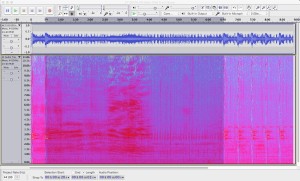
Below is a 2-minute recording of the Orcasound hydrophone (by another hydrophone network citizen scientist) at 11 a.m. on 1/13/16 containing 4 sonar ping sequences. Each sequence lasts 30 seconds and contains a series of complex rising tones followed by single 3.75 kHz tones at about 9 and 22 seconds into the sequence.
Spectrogram of the final 4 repetitions of the more complex sonar sequence.
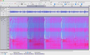
Spectrogram showing the detailed pattern of sounds during one of the more complex sonar sequences.
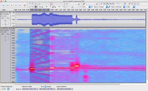
Individual sonar ping at 10:55
Recorded and provided by Jeanne Hyde, this ascending sonar sequence is relatively simple —
Spectrogram of a single ping on the Orcasound hydrophone at 10:55 a.m.
Individual sonar ping at 11:00 (1:14 into ~2hr 26 min recording)
In comparison, this recording (provided by Jeanne Hyde) captures one of the more complex sonar sequences —
Spectrogram of 0.5 second sonar pings at 3.25, 6.5, and 9.75 kHz recorded on the Orcasound hydrophone.
Comparison with SQS-53C sonar pings from 2003 Shoup event
This historic recording from 2003 is similar (relatively abbreviated) to the single ping at 10:55 —
Spectrogram of a single ping from the SQS-53C sonar during the 2003 Shoup incident.
In comparison, here’s one of the more complex sonar sequences observed on 1/13/16 —
Complex sonar sequence recorded in Haro Strait on 1/13/2016.
Overall, the ~10-second sequence has fundamentals and pure tones are between 2.5-3.75 kHz. This makes it distinct (lower frequencies) from the 6-8 kHz tones of Canadian SQS-510 system.
The initial 0.5-second tone has fundamental at 3.20 kHz rising to 3.35 kHz, with intense harmonics at 6.43-6.60 and 9.60-9.90 kHz.  This is followed by a 1.0-second pure tone at 3.45 kHz.
A second 0.5-second tone rises from 2.50-2.63 kHz, with a weak first harmonic at 5.0-5.2 kHz and a moderately intense second harmonic at 7.5-7.8 kHz. This is followed by a 1.0-second pure tone at 2.73 kHz.
There’s a third pair of rising and pure tones at intermediate frequencies, followed by a pause for reverberations/listening, and then a repeat (at lower source level?) of the second and initial phrases. Finally, there is an ending 0.5-second pure tone at 3.75 kHz.
Ship tracks and descriptions
The Canadian frigate Ottawa was observed in Haro Strait at the time of the sonar pings. If the time of the recordings and AIS locations are accurate, then the Ottawa was approximately 8-16 km north of Lime Kiln and Orcasound when the sonar sounds were recorded at those hydrophone locations.
Learning about the ecosystem an organism belongs to is often just as important as learning about the organism itself, so that’s what Beam Reach 112 set out to do for the first few weeks on land. We were fortunate enough to be able to set up our land based research at the Lime Kiln lighthouse where the orcas are seen frequently (usually!). Though the orcas managed to elude us the majority of the time we were at the lighthouse, we had no shortage of research we could do.
Marine Mammal and Bird Observing:
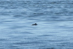
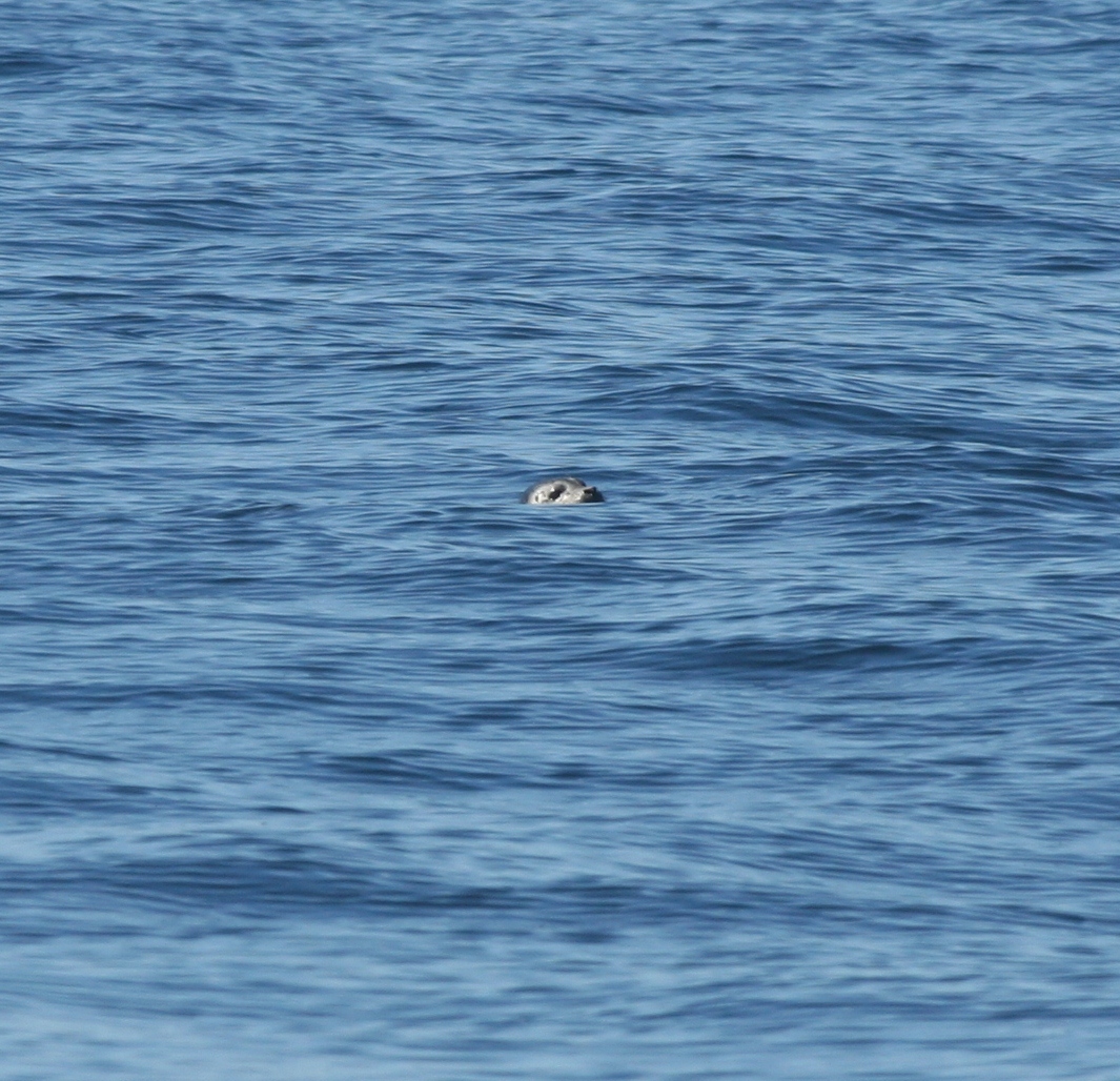
Each day at the lighthouse, one person was on observation. For 45 minutes at a time, every bird and mammal spotted was recorded. Seagulls, Cormorants, Murres, Dall’s porpoises, Harbour porpoises, and playful seals were regulars at the lighthouse on pretty much a daily basis.
Harbour porpoise and a peeking seal observed from the platform infront of the Lime Kiln lighthouse.
Underwater Camera Monitoring:
An underwater splashcam was installed directly infront of the lighthouse with the first hydrophone and the, also newly installed, CPODs (for detecting dolphin and porpoise clicks) in view. One person’s duty was to record everything that swam infront of the splashcam on paper and as 10 minute video recordings. We often had kelp greenlings and rockfish hanging around in view, taking the occasional nap ontop of the CPODs, or swimming up to give the camera a big kiss. We also got footage of the occasional large lingcod, seals swimming past, and schools of salmon swimming north (headed for the Fraser River?).
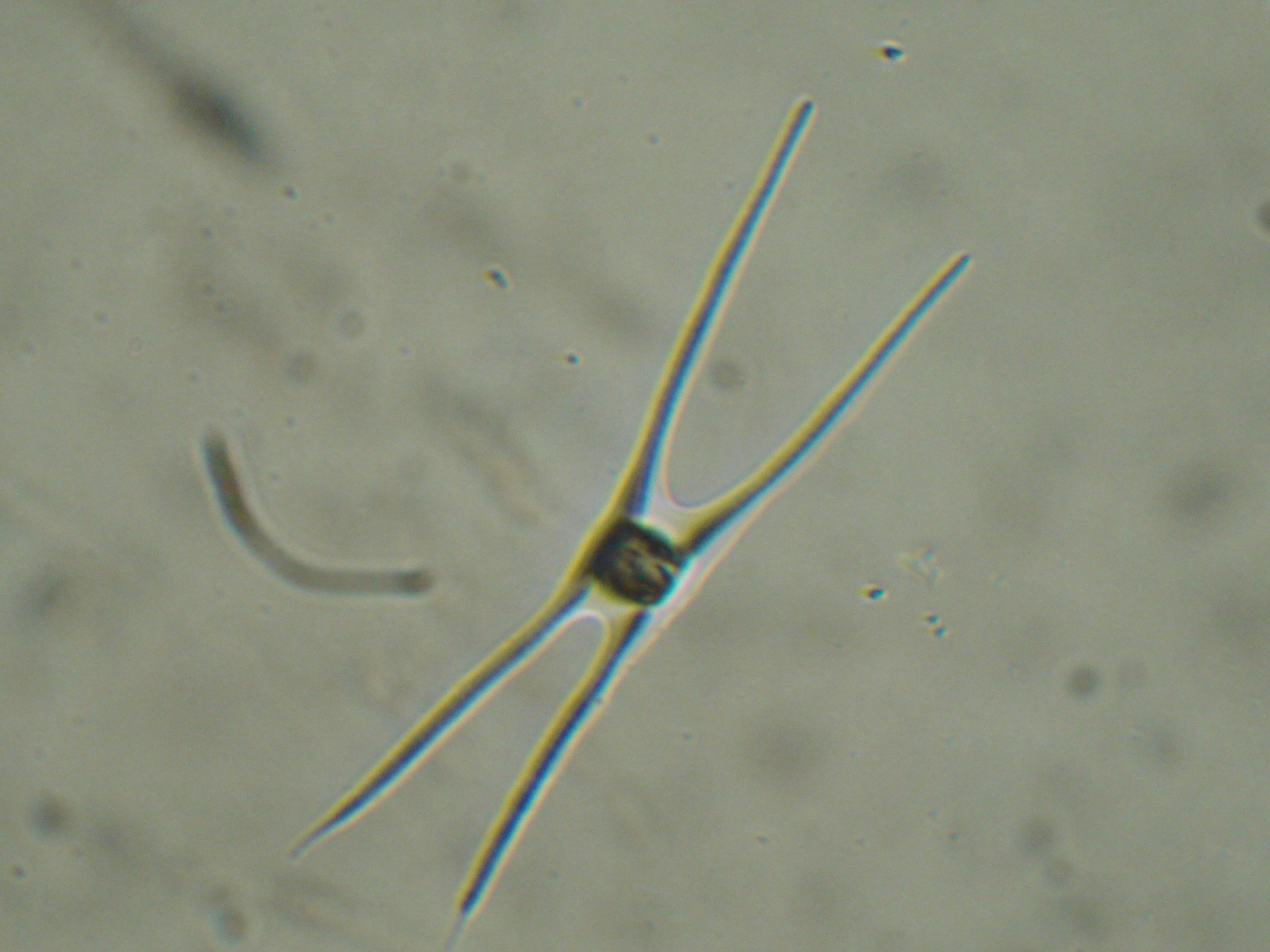
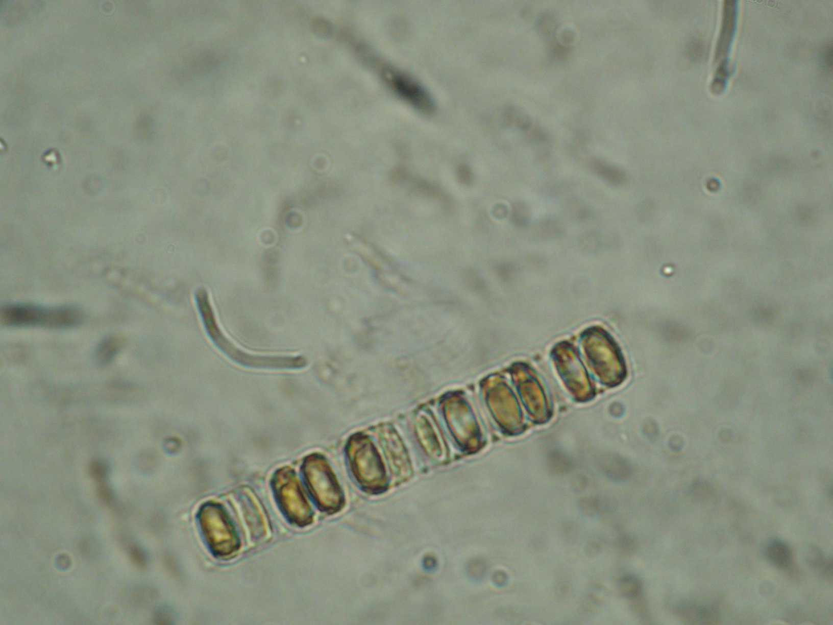
Using a YSI monitor, two people recorded water temperature, salinity, and dissolved oxygen daily. Then they also took a plankton tow and attempted to identify as many species as possible. The average water temperature was 10.85°C, average salinity was 28.95ppt, and average dissolved oxygen was 6.25mg/L. Some of the most commonly identified plankton species were Chaetoceros, Cylindrotheca, and Skeletonema.
Chaetoceros (left) and Skeletonema (right) found in samples collected at the Lime Kiln lighthouse.
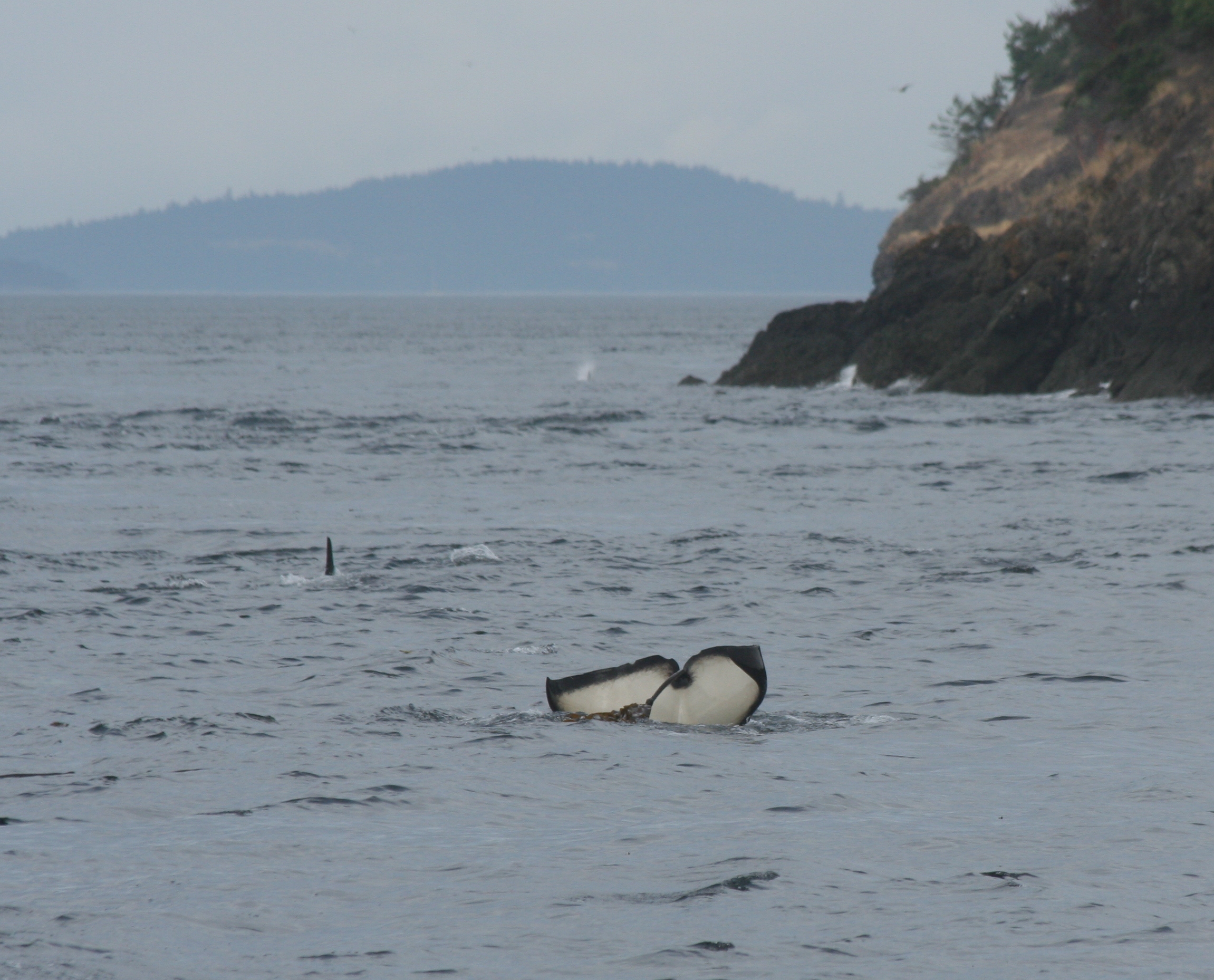
Orcas!
When we finally caught the orcas swimming past the lighthouse, we were ready to spring into action. One person started recording and monitoring the hydrophones. Audible calls and clicks were recorded on a phonation sheet so that we could go back and listen to the best times of the audio recordings. The other three of us headed down to the “iron post†infront of the
lighthouse, armed with a behaviour sheet, binoculars, and the camera. The goal was to record clock orientation (to the iron post), travel direction, distance, and any surface active behaviours, and attempt to get as many identification pictures as possible. This information goes into the Beam Reach archives to help with future projects, and can be used to help us confirm localizions of calls from the hydrophone recordings.
Orcas passing by the Lime Kiln lighthouse on September 15, 2011
Our time at the Lime Kiln helped us learn about the “big picture” of all the pieces of the orcas’ environment. Though it was kind of hectic (yet extremely exciting) when we did get to record orca data, it gave us a good introduction to what life on the Gato Verde would be like…
Another week has passed here on the San Juan Islands, and overall, it has been an adventure indeed.
This week, logistically, we went over a lot on statistics, acoustics, and equations that would scramble the neurons in your brain. I did my best to keep up with the work. On Monday as I recall, we were able to head down to the dock to collect sound data. We all had great practice in using the sound equipment, in preparation for our main research projects that are coming up. Gathering the data was a lot of fun, because we finally got a chance to get hands-on with what we were doing. We hung a speaker on one side of the dock and kept it there, as we inched our way down the dock with the hydrophone, measuring at different distances. With the data set we collected, we used what we learned in statistics and sound to start on our dock spreading exercise.
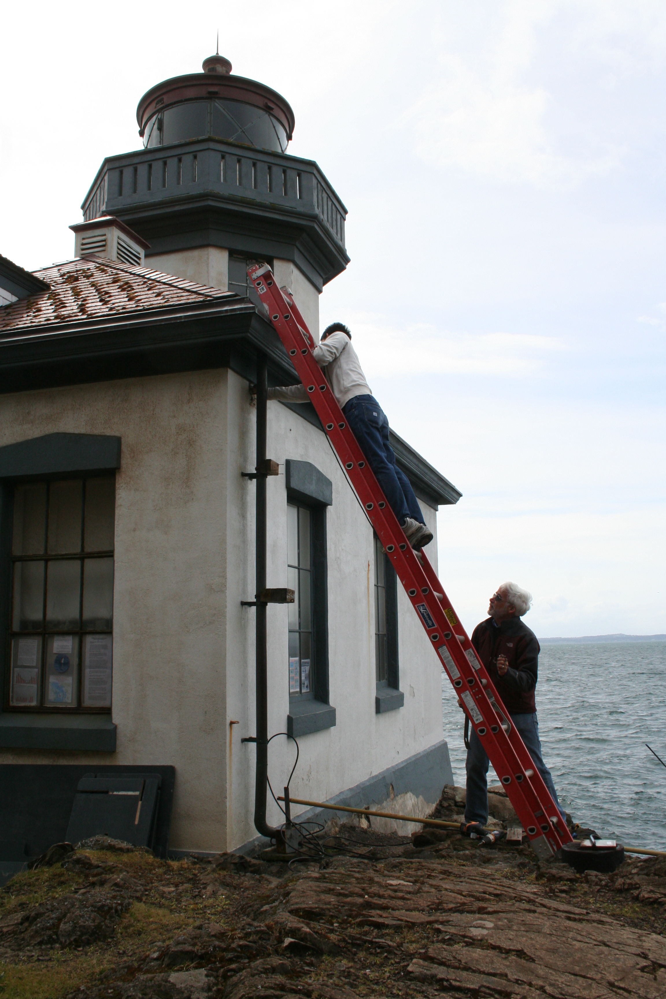
On Tuesday afternoon, we went back to the Lime Kiln Lighthouse to do some cleaning! It felt very refreshing to just contribute to the status of the lighthouse itself. I helped Val move the lighthouse antenna to the top of a tall post nearby. It was a hassle to get through those feisty tree branches, for me and Val had an interesting time maneuvering through the branches with the ladder and our bodies. Once we got it up there though, we felt really accomplished with our task. Better yet, before we even got the antenna attached to the pole, Val climbed up the ladder to dismantle the older satellite dish. And guess what? It was supposed to come crashing down like we predicted, but those branches supported it. Anticipation of a giant falling satellite dish was ruined. But the entire afternoon was sort of an adventure already.
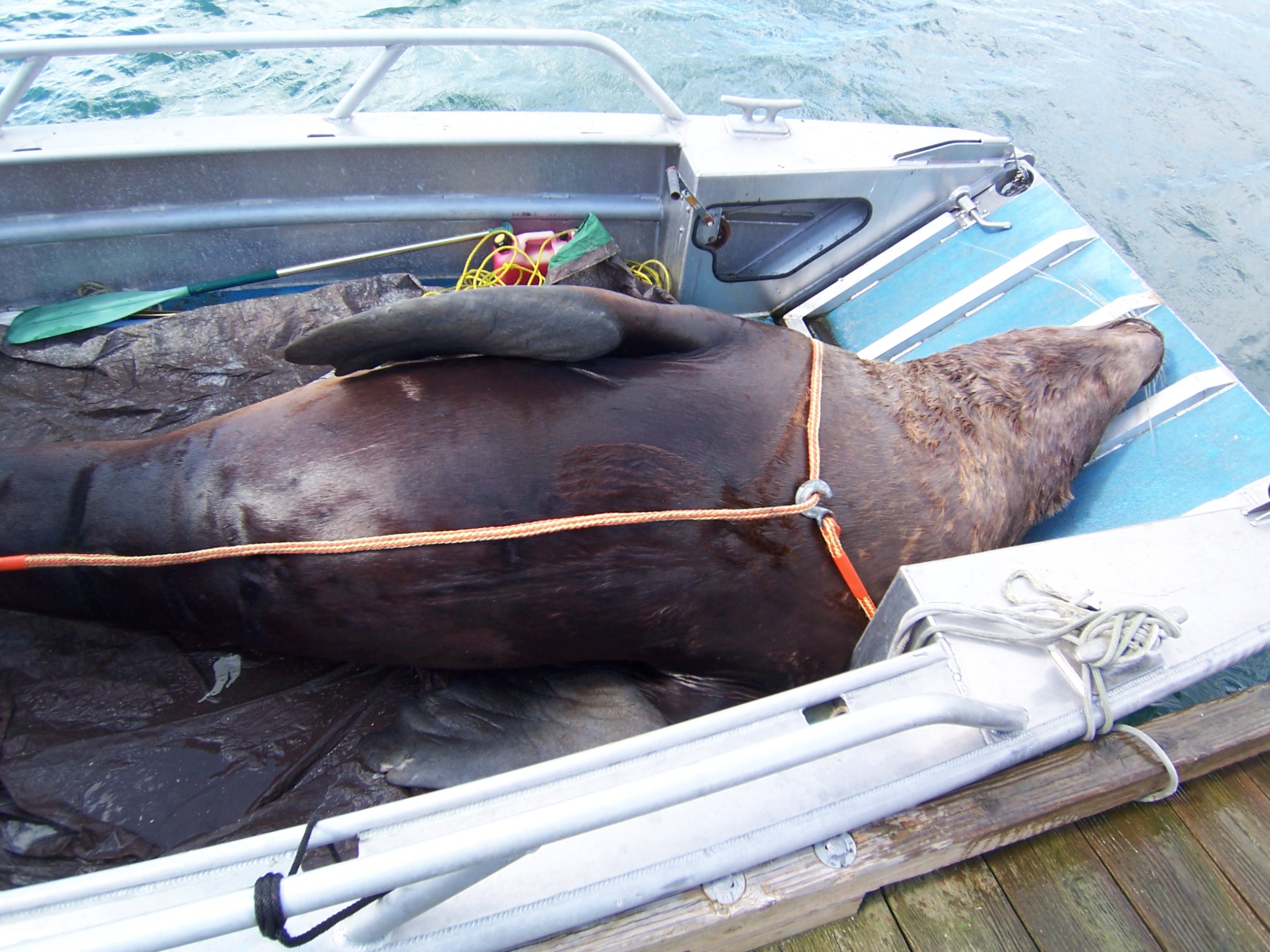
But the unexpected granted this week to be really adventurous indeed. Jason got a call to go pick up a Steller sea lion corpse off on one of the islands. And he called us to come along. So on Thursday, we needed out on the Buzzard, a small research vessel, to retrieve the corpse. It was a semi-windy afternoon when we left. We found it drifting alongside the shore of Lopez island. It was the first time I have ever seen such a humongous sea lion this close. It must have weighed over half a ton. After a tiresome couple of heaves, we got the humongous sea lion on board. However, the wind prevented us from going any further out in the open waters and thus, we had to leave it tied to the dock for the night. Even though we were not able to bring it back that exact moment, we began our trail back to the labs. The wind eventually grew much stronger, and water began to find its way into the boat. Because I sat on the front alongside Kathryn to balance the Buzzard, we ended up getting soaked from head to toe. But the whole journey was filled with nothing but jokes and laughter, even if we were getting pelted to the face by salt water. The next day, we set our course towards Lopez Island once more to retrieve that sea lion. This time, the sun was out with the least amount of wind that I have experienced here on the islands. Once we brought it back after an hour long boat ride, we contacted the people to perform a necropsy on the sea lion. I have never been so intrigued about anatomy in my life, after seeing a grown male Steller get dissected in front of my eyes. And to top the morning off, we were taught how to sail by Val in the afternoon! Nora and I made a couple of 360 degree turns out in the waters as Val and the others laughed. We figured how to get back to the dock eventually.
We finally finished our research proposals on Thursday and just got them returned an hour ago. It is soon getting closer and closer to the day when we actually can sail out and do our research!
I have been waiting to return to San Juan Island for 5 years. The first time I came to Friday Harbor, I was 15 years old. I arrived in Washington with the hopes of seeing a wild orca, and I began my hunt on the ferry to the island. I stood on the chilling bow, wind-whipped and shivering in 4 layers of clothing, scanning the horizon for black dorsal fins and telltale plumes of mist suspended in the air. I knew the chances of seeing whales before I had even reached San Juan Island were slim, but I simply could not contain my excitement. About halfway through the ferry ride, I noticed a zodiac idling a mile or so away. The people on the boat were obviously looking at something, and I squinted my eyes to get a better look. Moments later, a black shape rose out of the water, and my heart skipped a beat – orcas. Somehow my father managed to snap a photo of me at this exact moment, and I can only describe the expression on my face as one of pure, unadulterated joy. In suburban Ohio where I grew up, the closest thing to wild orcas are captive animals who lead sad half-lives at Sea World; it was an absolute thrill to see these animals swimming freely in the Salish Sea. This unexpected encounter set the trend for the remainder of my trip – I saw orcas nearly every day. I watched whales cruise by the lighthouse at Lime Kiln State Park and I followed them through the fog on a whale watch. The only way I managed to leave the island without dissolving into tears was to promise myself that I would return someday.
As I boarded the Anacortes ferry one week ago, I was overcome with the same child-like excitement I felt during my first ferry ride. I had waited so long to be reunited with this thick, fragrant air, the ethereal cathedrals of tall, leaning trees, and, most of all, the whales. After seven days on the island, I have still yet to see an orca, but my disappointment has been tempered by a multitude of other wildlife experiences. Friday Harbor Labs is situated within a biological preserve, and the area is bursting with life. I have had close encounters with deer, sea lions, slugs, foxes, and river otters, temporarily satiating my desire for animal contact. I have started to use our Sibley’s bird guide to identify the birds around our duplex (including a Red-Shafted Northern Flicker that has been drilling noisily on a metal lamp outside our window for the past few days) in an effort to hone my observational skills. While these experiences have been fulfilling, there is still part of me impatient to get out on the water – I listen to the hydrophone network daily, ears tweaked for sweeping killer whale calls, and even though I know they don’t frequent the east side of the island, I keep an ear out for the gunshot ring of whales coming up for air. We’ll be out at sea in two short weeks; in the meantime I will enjoy the company of other creatures and bask in the knowledge that I am finally back in this wonderful place.
David Howitt and Jason deployed hydrophone 2 and 1 in the North array today at around 2:00 pm. We moved the last two tires into place and placed another tire at the end of the cable protector to hold it in place. During the dive we resurveyed the original placements so that we had measurements from a single dive. The data collected are as follows:
Last Sunday (11/09/2008), Jason Wood and Scott Veirs deployed a receiver that can detect and record the signals emitted by acoustic tags implanted surgically in migratory fish, like the Chinook and chum salmon that southern resident killer whales appear to prefer. The Vemco “VR2″ receiver, provided by Fred Goetz through a collaboration with UW Fisheries, was deployed during a scheduled maintenance dive on the hydrophones at the Lime Kiln lighthouse. The plan is to retrieve the VR2 in early 2009, download any serendipitous detections that may help in the interpretation of the echosounder data (to be presented at the Puget Sound Georgia Basin conference), and then redeploy it for the remainder of the winter (and perhaps the entire year).
The dive went well and lasted from about 11-12am. We enjoyed visibility of about 20m and pleasantly calm seas (it was very rough on Saturday when we initially planned to dive). We cleaned and secured the intertidal hydrophone and echosounder cable protectors, checked the VR2 mooring for buoyancy, and then followed the hydrophone cable to the two hydrophone stands (cement-filled paint-buckets with a broad tripod of embedded rebar). The VR2 was deployed 3m NW of the southern hydrophone and its mooring anchor was tethered to that hydrophone stand’s embedded chain and one of its rebar legs.
The VR2 mooring had a total height above bottom of 2m, with the receiver hydrophone oriented upwards about 1.4m above bottom. Since the mooring was deployed in 9m of water when the tidal height was ~2m, the depth of the receiver is about 6m below the tidal datum (0m). The mooring consists of a ~2m length of 1/2″ 3-strand polypropelene line connecting a ~3kg buoyancy crab float (used in lieu of an incompressible trawl float since minimal compression is expected at this depth), the VR2 (cabled-tied through and around the strands), and a stainless steel threaded shackle (bowlines at both ends). The shackle connects to a loop of 3/16” plastic-coated wire rope that extends through a pier-block (via a 3/4 inch hole drilled through center line). The loop is secured with a clamp and is attached via sheet-bend to the ~4m-long tether (same type of line). All knots’ tails are secured with electrical tape. The float is marked with UW Fisheries research and Scott’s cell phone number.


 Twitter
 LinkedIn
 Facebook