U.S. Navy starts 2016 by pinging in the pool
With transient killer whales in the area and the whereabouts of J and L pods (and their many newborns!) unknown, we were concerned to hear that active sonar was utilized late in the morning on Wednesday, January 13, in Haro Strait — critical habitat for species in both Canada and the U.S. At the same time, military training activities were planned or taking place on both sides of the border. This is what it sounded like underwater along the western shoreline of San Juan Island —
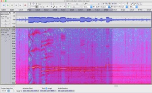
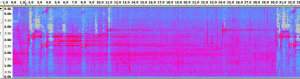
Complex sonar sequence recorded in Haro Strait on 1/13/2016 via the Orcasound hydrophone (~5km north of Lime Kiln State Park).
When the sonar was heard and recorded by members of the Salish Sea Hydrophone Network the Canadian Naval vessel HMCS Ottawa was observed (via AIS) transiting Haro Strait in U.S. waters about 10-20 km north of the hydrophones.
This juxtaposition led us to initially assert that the Ottawa — a Halifax class frigate which carries active sonar — was the source of the sonar pings, reinforced by the activation of the test range (area Whiskey Golf off Nanaimo) on 1/12 and 1/14. However, a proactive call to Beam Reach on 1/14/16 from Danielle Smith, Environmental Officer for Canadian Forces Base Esquimalt, suggested that the Ottawa was not the source. Specifically, she stated that active sonar use was not in their plan when they last departed. She also said she spoke directly with the Ottawa’s Commanding Officer who confirmed with the crew that the transducers were not lowered, and that therefore there was no way their SQS-510 (medium frequency search sonar system) could have transmitted (e.g. sometimes calibrations underway go unreported). Finally, she communicated that their senior sonar techs were confident that the recorded frequencies were not consistent with the Ottawa’s 510 system. When asked, she confirmed that the sonar system had not been upgraded since it was last recorded during the 2012 vent in which the Ottawa disturbed and possibly damaged the endangered Southern Resident Killer whales.
Other sources of information also suggest that the U.S. Navy may have been the source of the sonar pings.
First and foremost, the sonar pings are distinct from the active mid-frequency SQS-510 sonar used by the Ottawa in February, 2012. Instead, they sound similar to, but are more complex than the SQS-53C pings emitted by the U.S. destroyer Shoup on May 5, 2003. [They were also coincident with many individual broadband pings spaced about 6.6 seconds apart. Were these made by the vessel with the active sonar, or a different one?]
Furthermore, comparison of the times of the recorded sonar pings and available AIS tracks suggests that the sonar was recorded when the Ottawa was located between the north Henry Island and Turn Point at the northwest tip of Stuart Island. If the source was the Ottawa, why would it have utilized sonar only while within U.S. waters (about 1-2 km east of the International Boundary). During this period, the Ottawa was about 8-16 km north of the recording hydrophones. Pending computation of the calibrated received levels, the qualitative intensity of the received pings suggests that the source was closer than the Ottawa’s AIS positions allow.
Smith’s statements and these observations raise a key question:Â were U.S. vessels in the area emitting these sounds that are similar to those emitted by the US destroyer Shoup in 2003?
This possibility is alarming because the U.S. Navy has refrained from training with active sonar within the Salish Sea since the Shoup sonar incident of 2003 (which disturbed endangered Southern Residents, as well as a minke whale and harbor porpoises). (The U.S. Navy has tested sonar since the Shoup incident: during the San Francisco submarine event of 2009 and the Everett dockside event in 2012.) Also, the U.S. Navy more recently has agreed to minimize the impacts of its mid-frequency sonar.
Portending a worrisome trend, at the start of 2016 news surfaced that the U.S. Navy planned operations in the Pacific Northwest that might include “mini-subs” and beach landings beginning in mid-January, 2016. No recent AIS tracks of US military vessels have been archived by marinetraffic.com, suggesting that the Navy vessels’ AIS transceivers may have been turned off based on their mission.
Visual observations demonstrate that U.S. Naval ships were active on 1/13/20016. At least one U.S. Naval ship, possibly a frigate, was seen departing Everett around mid-day by Orca Network. Slightly earlier, between 10:30 and 11:30 a.m Howard Garrett of Orca Network saw two Navy ships transiting northward up Admiralty Inlet about 15 min. apart. The first one looked like the Shoup, complete with the cannon on the bow; the second looked more like a supply ship.
(1/17/16 update: A citizen scientist observed two Naval ships southbound in Haro Strait between Turn Point and D’Arcy Island at around 10:45 a.m. — roughly coincident with the sonar heard on the nearby Orcasound hydrophone. 1/19/16: Navy Region Northwest has confirmed a U.S. Naval ship was “in the area…”)
Update 1/22/16: Navy Region Northwest Deputy, Public Affairs, Sheila Murray stated in an email to Beam Reach,
“A U.S. Navy DDG was transiting within the Strait of Juan de Fuca on the U.S. side of the waterway (not in or near the Haro Strait). The DDG confirmed sonar use consistent with recordings on the Beam Reach Facebook page for a brief period of time, approximately 10 min. There were trained lookouts stationed during this event. No marine mammals were sighted during the activity and no marine mammal vocalizations were detected by passive acoustic monitoring. The ship was briefly operating its sonar system for a readiness evaluation in order for the ship to deploy in the near future.”
It is not clear whether the DDG (Guided Missile Destroyer) was one of the Everett-based ships — the Shoup or Momsen — or if it was based elsewhere (e.g. one of the 15 destroyers stationed in San Diego). [Update 1/25/2016: Navy Region Northwest has, however, re-directed a question from Beam Reach regarding the procedures followed by the ship to the Third Fleet (based in San Diego) suggesting that the DDG may have been based in California.]
Update 2/4/16: Lt. Julianne Holland, Deputy Public Affairs Officer Commander, U.S. Third Fleet responded to a question posed by Beam Reach,
Below is the response to your question: Did the DDG obtain permission from the Commander of the Pacific Fleet in advance of this use of MFAS in Greater Puget Sound?
The Navy did not anticipate this use within the Strait of Juan de Fuca. The use of sonar was required for a deployment exercise that was not able to be conducted outside of the Strait due to sea state conditions. The Navy vessel followed the process to check on the requirements for this type of use in this location, but a technical error occurred which resulted in the unit not being made aware of the requirement to request permission. The exercise was very brief in duration, lasting less than 10 minutes, and the Navy has taken steps to correct the procedures to ensure this doesn’t occur again at this, or any other, location. The Navy also reviewed historical records to confirm this event has not occurred before and was a one-time occurrence within the Puget Sound/Strait of Juan de Fuca. The Navy reported the incident to NMFS and NMFS determined that no modifications to the Navy’s authorization are needed at this time.
Below is a chronology of events, wildlife sightings, and acoustic analysis that we hope will help document the event, including the source of the sonar and any impacts on marine life of the Salish Sea.
Key events (local time, PST):
Tue 1/12/16 14:30 PST: Ottawa in search pattern all afternoon and night (1-7 knots, east of Constance Bank)
Wed 1/13/16 09:00 PST: Ottawa moves north into Haro Strait
Wed 1/13/16 10:00 PST: Ottawa enters U.S. waters between False Bay and Discovery Island, proceeds north
Wed 1/13/16 10:45 PST: Intense sonar pings recorded on the Orcasound hydrophone (originating from a U.S. destroyer in the Strait of Juan de Fuca)
Wed 1/13/16 11:00 PST: Ottawa leaves U.S. waters near Turn Point, Stuart Island
Detailed Chronology (public Google spreadsheet):
Acoustic recordings and analysis
8 minute recordings from Lime Kiln and Orcasound
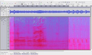
Jeanne Hyde provided 2 recordings — each about 8 minutes long — of a sequence of sonar pings. The first is from the Lime Kiln lighthouse hydrophone (but we believe there is some drift in the time base, so this recording should not be used to assess event timing, like sonar initiation, duration, or ping intervals) —
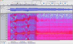
Lime Kiln 8-minute recording (10:41)
Spectrogram of 8-minute recording from the Lime Kiln hydrophone.
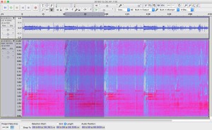
— the second is from the Orcasound hydrophone (about 5 km north of Lime Kiln) —
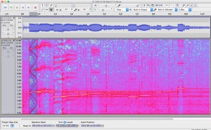
Orcasound 8-minute recording (10:55)
Spectrogram of 8-minute recording from the Orcasound hydrophone.
Assuming that drift in the Lime Kiln recording has corrupted its time base, we use the Orcasound to establish timing of the event. Overall, the event consists of a pattern of broadband pulses and ~30-second sequences of frequency modulated (FM) slide and narrowband continuous wave (CW) pulses. The ~9-minute pattern was: two simple, ascending FM+CW sequences, 52 broadband pulses (2.5-3.0 kHz) about 6.7 seconds apart, and then 5 more FM+CW sequences.Â
The initial and final FM+CW sequences were distinct. The first two were relatively simple and consisted of: a 2.5-2.6 kHz rise for ~0.5 seconds, 2.75 kHz tone for ~1 second, another 0.5 second rise from 2.85-2.95 kHz, and finally a 3.1 kHz tone for ~1 second. The more complicated sequence that is repeated 5 times at the end of the sonar event (around 11:00-11:03 a.m.) is described below (in the section that makes a comparison with SQS-53C sonar sequences emitted by the Shoup in 2003).
The broadband pulse echoes were audible and were received on average 3.4 seconds after the direct path pulse. This time delay indicates a mean extra distance traveled of about 5 kilometers, though there was a clear trend from about 5.7 to 4.4 km over the course of the 52 pings.
Further quantitative analysis of the acoustic data is included in the 13 Jan 2016 sonar chronology Google spreadsheet. The larger data files are archived and shorter clips and associated spectrograms are embedded below.
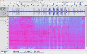
Sonar sequence repeated 5 times around 11:00
Below is a 2-minute recording of the Orcasound hydrophone (by another hydrophone network citizen scientist) at 11 a.m. on 1/13/16 containing 4 sonar ping sequences. Each sequence lasts 30 seconds and contains a series of complex rising tones followed by single 3.75 kHz tones at about 9 and 22 seconds into the sequence.
Spectrogram of the final 4 repetitions of the more complex sonar sequence.
Spectrogram showing the detailed pattern of sounds during one of the more complex sonar sequences.
Individual sonar ping at 10:55
Recorded and provided by Jeanne Hyde, this ascending sonar sequence is relatively simple —
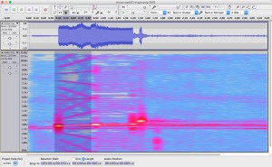
Spectrogram of a single ping on the Orcasound hydrophone at 10:55 a.m.
Individual sonar ping at 11:00 (1:14 into ~2hr 26 min recording)
In comparison, this recording (provided by Jeanne Hyde) captures one of the more complex sonar sequences —
Spectrogram of 0.5 second sonar pings at 3.25, 6.5, and 9.75 kHz recorded on the Orcasound hydrophone.
Comparison with SQS-53C sonar pings from 2003 Shoup event
This historic recording from 2003 is similar (relatively abbreviated) to the single ping at 10:55 —
Spectrogram of a single ping from the SQS-53C sonar during the 2003 Shoup incident.
In comparison, here’s one of the more complex sonar sequences observed on 1/13/16 —
Complex sonar sequence recorded in Haro Strait on 1/13/2016.
Overall, the ~10-second sequence has fundamentals and pure tones are between 2.5-3.75 kHz. This makes it distinct (lower frequencies) from the 6-8 kHz tones of Canadian SQS-510 system.
The initial 0.5-second tone has fundamental at 3.20 kHz rising to 3.35 kHz, with intense harmonics at 6.43-6.60 and 9.60-9.90 kHz.  This is followed by a 1.0-second pure tone at 3.45 kHz.
A second 0.5-second tone rises from 2.50-2.63 kHz, with a weak first harmonic at 5.0-5.2 kHz and a moderately intense second harmonic at 7.5-7.8 kHz. This is followed by a 1.0-second pure tone at 2.73 kHz.
There’s a third pair of rising and pure tones at intermediate frequencies, followed by a pause for reverberations/listening, and then a repeat (at lower source level?) of the second and initial phrases. Finally, there is an ending 0.5-second pure tone at 3.75 kHz.
Ship tracks and descriptions
The Canadian frigate Ottawa was observed in Haro Strait at the time of the sonar pings. If the time of the recordings and AIS locations are accurate, then the Ottawa was approximately 8-16 km north of Lime Kiln and Orcasound when the sonar sounds were recorded at those hydrophone locations.
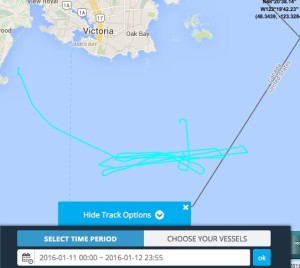
AIS track of the Ottawa on 1/11 to 1/12.
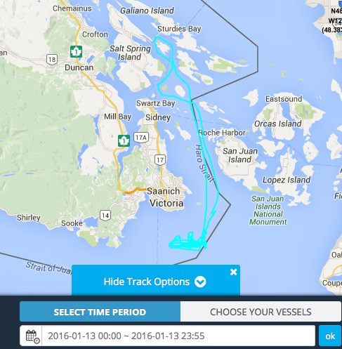
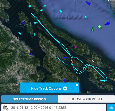
AIS track of the Ottawa on 1/13.
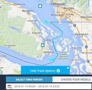
AIS track of the Ottawa on 1/14.
Alternative Ottawa track map
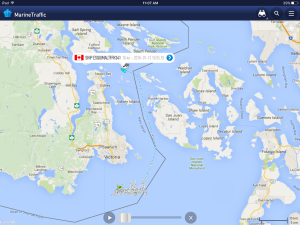
The Canadian Orca class patrol vessel, Caribou 57, was also active and tracked on AIS. From Tuesday 1/12 noon through 1/13 it was patrolling withing the southern Gulf Islands.
Track of the patrol vessel Caribou 57 on 1/12-13.
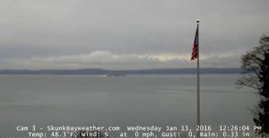
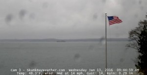
Possible US Naval ships in/outbound from Everett on 1/13/2016 (Skunk Bay web cam):


 Twitter
 LinkedIn
 Facebook