When will ferries in British Columbia stop killing orcas?
Call to action: email the Minister of Fisheries and Oceans in Canada, the Honourable Jonathan Wilkinson, at min@dfo-mpo.gc.ca and ask him to publish the full necropsy report and all other information known to the Canadian government to be related to the death of Southern Resident Killer Whale (SRKW) J34!
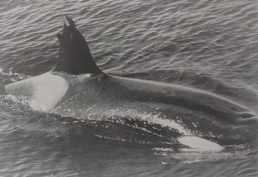
Most folks think that killer whales — top predators of the ocean — are too fast and smart to get hit by big ships. But, if you look back through the history of salmon-seeking orcas over decades of growing human population and vessel traffic, a long list of injury and death reveals that they are sometimes struck by big ships (as well as by small boats), including within the Salish Sea. The starkest example is a collision in 1973 with a B.C. ferry that killed a young orca.
The Comox ferry incident (1973)
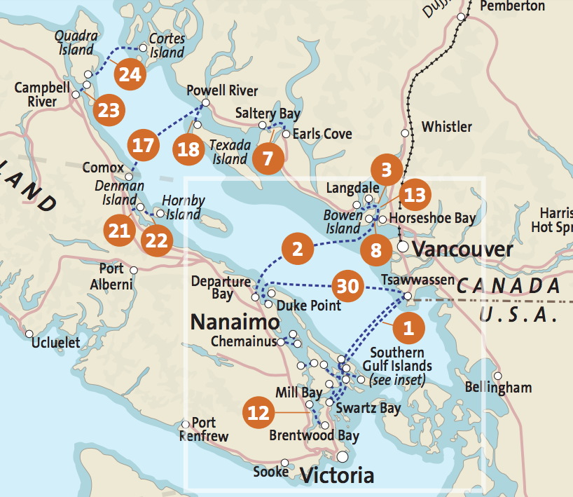
A clear case in which a ferry in B.C. struck a resident orca was an incident described in the 2nd edition of a book called “Killer Whales” (Ford et al., 2000; see excerpt below & this photo album with the relevant pages). On 26 December 1973, en route from Comox on Vancouver Island to Powell River on the BC mainland (see #17 on the map below), the BC Ferry “M/V Comox” struck a juvenile northern resident killer whale (A21).
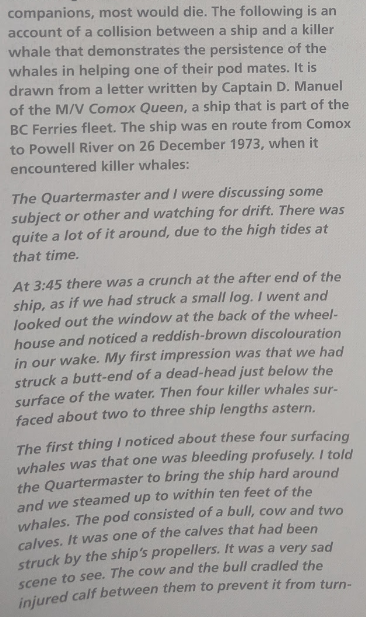
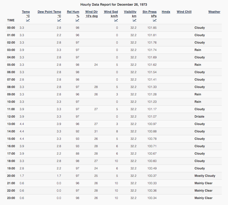
No whales were sighted prior to the collision of the orca and the ship’s propeller, but conditions are rarely optimal for marine mammal observers in the northern Strait of Georgia in late December. The Captain noted that there was a lot of debris in the water that day. And based on the hourly weather report that day in 1973 (see below), there was some rain in the morning, and by late afternoon (3:45 pm) it was overcast with rising light winds, probably resulting in some chop.
It was also late in the day, that close to the winter solstice (December 21). According to a sunset calculator, that Wednesday the sun set at 16:24, just ~45 minutes after the strike occurred. Since the ferry was bound for Powell River (heading west-northwest), any low-angle sunlight would have been coming over the port stern quarter, making visibility in that direction more difficult. Some direct light from the setting sun slipping under the overhead clouds seems likely given that the winds were out of the west that afternoon and evening, and the skies cleared some 4 hours later. In any case, in the direction the ferry was headed (to the east) there was no backlighting from the sun — a situation which often makes killer whale blows much easier to see at a distance.
Somehow, the Captain and crew failed to observe the 4 killer whales until after the impact of one of the two calves with the propeller was heard. Maybe visibility was too low, maybe they were distracted (they mention conversing at the time), or maybe the orcas converged from an aft quarter hidden by the glare of the setting sun. What was observed when the ferry returned to the scene was a lot of blood in the water, propeller lacerations along the injured orca’s flank, and the parents trying to keep their calf upright.
The Captain assumed that the injured orca would soon die and the ferry continued on to Powell River. Surprisingly, it was observed 15 days later, still being assisted by its parents. This is another example of the persistent, strong bonds in orca families, and the duration of the parent’s efforts bears an uncanny resemblance to the 17-day “tour of grief” by J35 with her dead calf last summer. Unfortunately, A21 was never sighted again, so we can safely conclude that the collision was fatal.
That’s the strongest evidence that salmon-seeking orcas are sometimes killed by big ships within the Salish Sea, in this case specifically by a BC Ferry. But there are many other strikes of orcas that have been documented in BC and Washington State (e.g. Williams & O’Hara, 2010). Here is a working list of vessel strikes on killer whales, as well as other cetaceans, in the region:
The case of southern resident killer whale J34 (2016)
The most recent possible strike of a fish-eating killer whale is the stranding of J34 (aka “Doublestuf”) an adult male endangered southern resident discovered floating dead just north of Vancouver, BC, in December, 2016. While all available information about the death of J34 is currently insufficient to determine the cause of the “blunt force trauma” that killed him, the most parsimonious interpretation is that he was struck by a vessel.
The hypothesis that J34 was killed by a vessel was proposed very early in the DFO response to the incident. Just a day after J34’s body had been towed to a beach near Sechelt for a necropsy, DFO Pacific Region Marine Mammal Coordinator Paul Cottrell said in an interview with CTV (at 1:00): “Vessel strike could be a potential… and something we’ll be investigating going forward.”
That investigation has been on-going for 2.5 years now, with no final necropsy report available to the public and scientists. Such a report typically would contain important information about the health of the animal prior to injury, condition of the carcass, the mechanisms of injuries, and the most probable cause(s) of death. Beam Reach has made multiple requests for the report, but only a summary has been released. It’s starting to seem like science is being suppressed by some part of the Canadian Government well above the dedicated mariners, First Nations volunteers, and scientists who recovered the body and undertook a prompt, thorough necropsy and many important follow-up investigations, like a CAT scan of the skull to look for fractures, as well as tissue and blood analyses. It likely contains information that should be considered in important on-going conservation processes — like Canada’s Technical Working Groups and the environmental reviews of both the Transmountain pipeline and Roberts Bank container ship terminal expansions.
But even without the final necropsy report, under the assumption that J34 was struck by a vessel, we can make some initial inferences about what type of vessel it was. Here’s a synopsis of what we know and can infer:
- The location of J34 floating just south of the Trail Islands is established by the AIS/GPS location of the Canadian Coast Guard vessel that towed the body to shore.
- The drift of J34 to the point of discovery can be assumed to have been north-northwestward, based on predominant winds (from the south-southeast) measured during the previous week.
- This drift direction suggest that vessels that commonly ply routes south of Sechelt would have been most likely to strike J34.
- The object responsible for the blunt force trauma suffered by J34 along his side and head was powerful enough to shatter the bone on the inside of his skull, leaving “spicules and sheaves up to 3-4 cm long” within his brain cavity.
- By far the most prevalent type of powerful vessel in the direction of drift are the B.C. Ferries that traverse the Strait of Georgia many times per day on three major east-west routes. The closest is the Horseshoe Bay to Departure Bay route, only 20 km to the south of the discovery site (with ~10 transits/day at that time of year, according to the December 2019 schedule)
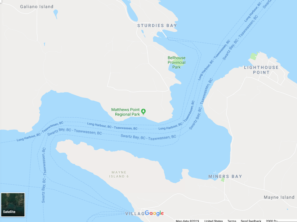
The spatial relationship of these observations, including the estimated drift direction and inferred (hypothetical) collision sites within B.C. ferry routes are indicated in this static version of the J34 stranding map:
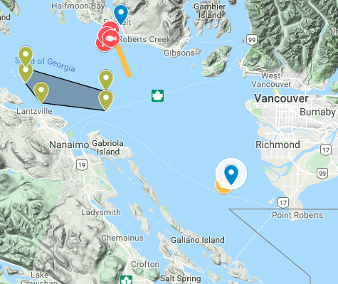
The intersection of the ferry routes by a linear extension of the orange drift line occur at about 20, 40, & 70 km, respectively for the Horseshoe Bay – Departure Bay, Tsawwassen – Duke Point, & Tsawwassen – Swartz Bay routes. An important constraint that the final necropsy report could offer is how long J34 had been drifting before he was discovered. All we know now — again from the CTV interview with Paul Cottrell — is that “This animal was very fresh…” With no quantitative estimate of the number of hours or days J34 was adrift, this qualitative condition suggests the the collision could have been local — possibly indicating that the closest ferry route was the most-likely location of a potential strike.
One depiction of the local traffic density in the period just prior to J34’s discovery is this map of AIS tracks:
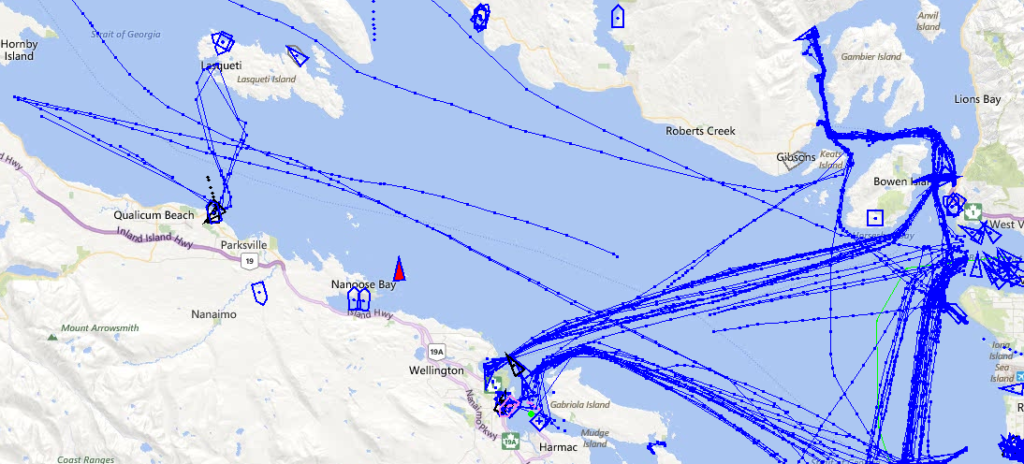
Note the typically high traffic density along the routes of the B.C. Ferries, as well as vessel traffic associated with Burrard Inlet in Vancouver. Now take a look at this example of the best information we have about how SRKWs travel into and out of the northern Strait of Georgia during the winter months (Dec – Feb, based on satellite tags deployed by NOAA in 2014 and 2015):
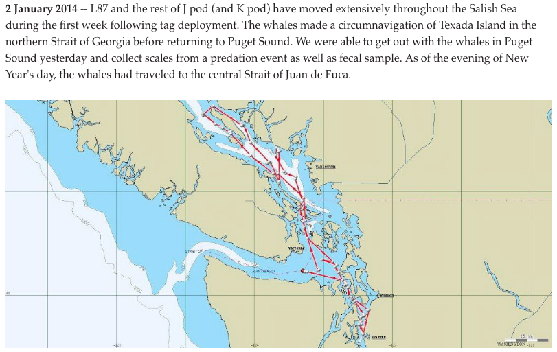
What jumps out at me is that during the winter, they tend to travel north-south while staying west of the commercial shipping lanes. This means that if J34 (in December) was following this pattern, his path would more-likely have crossed the east-west ferry lanes than the shipping lanes associated with Vancouver Island.
A sudden (suspicious?) interest in thermal cameras for BC Ferries
After many years of minimal action on both sides of the border, 2018 witnessed a tremendous acceleration in public and governmental will to help the SRKWs recover. Spurred in part by the global media attention garnered by J35’s tragedy, and catalyzed by a Washington Governor with Presidential aspirations and the political machinations of the Trudeau administration’s Ocean Protection Plan, a wave of new policy developments and investments rolled through the Salish Sea. The wave was propelled in WA by the SRKW Task Force (which met intensively in 2018 along with its Work Groups) while in Canada there were Technical Working Groups hard at work through the winter of 2018-19.
Amid this policy-making maelstrom in the Pacific Northwest, a detail at the very end of this news article from the East Coast of the U.S. made me stop in my tracks and think of J34:
June 13, 2019 Featured Project, WHOI online news & insights
The backstory and motivation of the research project — to avoid “ship strike” — made a lot of sense to me. It was a little ambiguous if by “ship” the young WHOI principal investigator, Dan Zitterbart, meant big vessels like commercial ships, or small vessels like recreational and whale watch boats, or both. But he was at least talking about strikes against the right types of Salish Sea whales: humpbacks, killer whales, etc. Perhaps Dan and the WHOI news editor were just not quite clear about which types of vessels have struck which types of Salish Sea whales in recent decades?
I started to feel a little more cognitive dissonance when I read that WHOI was “working with Transport Canada and B.C. Ferries” (emphasis added), though. “Wait. Why isn’t this a DFO research project?” I thought. “Isn’t DFO being funded through the Ocean Protection Plan for this sort of research?” Esteemed colleagues at DFO like Harald Yurk were quoted, though, arguing that an inter-comparison of thermal imaging and acoustic detection rates would be fruitful. As a coordinator of the Orcasound hydrophone network, this was starting to make good sense again. I began to think that maybe Transport Canada was funding the project and the involvement of the B.C. Ferries was limited to hosting the cameras on Galiano Island at the Sturdies Bay terminal — a site which I know provides a good vantage point for observing the busy summertime SRKW, boat, ship, and ferry traffic at the northeast end of Active Pass.
Cognitive dissonance was abating for me at this point in the article, because I knew that Paul Cottrell of DFO had put an enormous effort in improving DFO’s internal acoustic detection capabilities in the Gulf Islands and beyond. Plus, the article mentioned one of the DFO hydrophones being co-located with the camera study site.
But then, at the very end of the article, came the zinger. Dan was quoted as saying:
if the detection is effective enough, we could eventually think about mounting infrared cameras directly on the bow of ferry ships and having a real-time feedback loop where mariners are alerted to slow down if whales are present
Dan Zitterbart, assistant scientist at Woods Hole Oceanographic Institution
(See also attribution in this 6/27/19 derivative piece in New Atlas)
Why would a young investigator from Massachusetts volunteer that his advanced automated detection system should specifically be mounted “on the bow of ferry ships” as opposed to vessels in general? I can only surmise that B.C. Ferries is driving the development of this technology for their own ships — not just hosting a study that could supplement DFO’s acoustic tracking of whales or reduce vessel strikes in general.
Connecting the dots has disturbing implications. Did B.C. Ferries strike J34 in December 2016, pressure DFO to retain the final necropsy report for the last 2.5 years, and concurrently collaborate with DFO using Ocean Protection Funds (provided via Transport Canada) to develop high-tech detection systems? Did they do this to avoid a public relations nightmare in 2016-17 and instead appear in 2018-19 to be proactively engaged in preventing future SRKW mortality?
I hope this most-parsimonious interpretation is wrong, but I’m looking at all the data, struggling to understand why the necropsy report still remains unpublished, and sensing that…
Something smells increasingly fishy.
Possibly disgustingly fishy… like rotting Chinook in a long-dead orca.
Call to action: your last of Orca ACTION Month!
Researching and writing this post was my last action for the month of June — declared in Washington State to be “Orca Action Month.” As we ease into July and hope the SRKWs return to grace our urban estuary, I hope you’ll take one more action, too, regardless of whether you’re in WA, BC, or beyond.
Call to action: email the Minister of Fisheries and Oceans in Canada, the Honourable Jonathan Wilkinson, at min@dfo-mpo.gc.ca and ask him to publish the full necropsy report and all other information known to the Canadian government to be related to the death of SRKW J34!
Do it for science. Do it for J34.
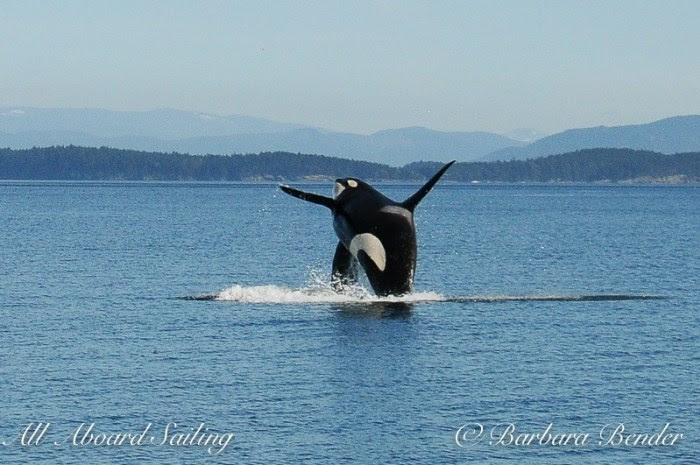
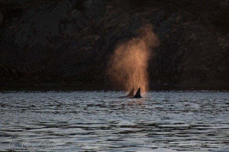
(Credit: Barbara Bender, All Aboard Sailing)
Post-script: A future without ferries?
Whether or not a ferry killed J34, there are many reasons to reconsider whether status quo (unquestioned growth of B.C. and Washington ferry traffic):
- The Tsawwassen ferry terminal has a problematic location and history. Due to an early 20th-century strike of private ferry workers, the Province took over the ferry service, and the terminal was hastily placed within the Fraser River delta with no environmental review. Now we know that area is summertime critical habitat of the SRKWs, as well as for the Fraser Chinook salmon the SRKWs prefer.
- Active Pass is a particularly terrible juxtaposition of SRKW habitat and dense vessel traffic.
- The prevalence of E-W ferry traffic in both Canadian and U.S. critical habitat for SRKWs (who mostly travel N-S) and other whales (like humpacks that are notoriously unpredictable in their surfacing patterns) constitutes a significant strike risk that may grow (e.g. as ferry traffic and/or humpback populations increase, or as SRKW population recovers).
- In our rush to get more people more places faster and faster, we should at least think about alternatives to motorized ferries — like bridges and tunnels. While the bathymetry of the Strait of Georgia — 50 km wide & 200 m deep — makes a bridge look difficult, there are bridges that are longer and support structures that reach deeper.
- A tunnel under the Strait of Georgia seems feasible, too, possibly more so. For example, a tunnel from Tsawwassen to Swartz Bay would need to be 43 km long and ~300 m at the deepest point (~100m below the bottom of the Strait). Two comparable sub-sea tunnels are the Seikan tunnel (54 km & 240 m below sea level) in Japan and the Chunnel between England and France (spanning 37 km of the Strait of Dover with a maximum depth of 115 m below sea level).
NOTE: This blog post presents the personal opinions of Scott Veirs, President of Beam Reach, a social purpose corporation based in Seattle, WA. These ideas are in no way related to or endorsed by the marine mammal work group of the Puget Sound Ecosystem Monitoring Program, which Scott currently chairs.


 Twitter
 LinkedIn
 Facebook