Thanks to a calm weather window and the on-going support of collaborators at the University of Washington and NOAA/NWFSC, we were able to re-deploy two fish tag detectors along the west side of San Juan Island in the first days of 2010. We plan to re-deploy a third in the first quarter of 2010. Stay tuned for a separate post summarizing what fish were detected in the last year or so. In the interim, here are some notes and photos from the field work.
Saturday 1/2/10:
During a hydrophone maintenance dive, Jason Wood and I deployed a new Vemco fish tag receiver (VR2W SN#100905) at Lime Kiln lighthouse. We supported the receiver on doubled crab pot line with a salvaged WDFW float (#3398) and anchored it with about 10 liters of concrete in a paint bucket with rebar/PVC legs. A length of chain embedded in the concrete served as an attachment point for both the receiver mooring (clipped on with a taped SS carabiner) and a tether which was tied to the first hydrophone stand.
The Lime Kiln mooring location is about 30m west of the iron bar near the high tide mark adjacent to the SW corner of the lighthouse. The mooring anchor depth is about 10m.
The highlight of the dive was Jason finding the old VR2W (SN#100914). After we had been led astray by an old yellow line, I was pretty sure we were in the wrong spot and wouldn’t have enough air to search for the old mooring. Yet we had to be close because we had encountered one of the old hydrophone stands whose pair should have been within about 10m. I was thinking about whether the old hydrophone stand might have been moved by the pesky Lime Kiln currents when Jason waved in front of my face. I looked up to see him smiling around his mouthpiece, the algae-encrusted old mooring in his grasp. It was a cinch to raise it with the lift bag and the exfoliated kelp hardly slowed our return to shore.
The VR2W looked great and the red light was confirmed still flashing once uncovered at the lighthouse picnic tables. The float was pretty overgrown with algae and the indelible ink was no longer legible.
Orcasound mooring ready to deploy
Sunday 1/3/10:
While the leaded line tethering the Orcasound VR2W to shore was intact as recently as NN months ago, when we looked for it late last night we found only a short section still attached to the intertidal eyebolt. Luckily the other end was found only a few meters away, pinned under a boulder by 10 cm of gravel. The remainder was entangled in nearshore subtidal rocks, but I managed to tease it out by wading around. I was able to wade to where it was attached to a braided nylon line. There I attached a crab pot float and then re-secured the leaded line to shore.
This morning, Liam helped Val and I pick up the float and back away from shore while taking up the nylon line. The mooring came up fine (though a thicker line for that concrete weight would be easier on the hands) and the red light on the VR2W (SN#100913) was still flashing!
After laying out the new hydrophones (to ensure we didn’t overlay the new Vemco tether), Jason paid out some extra slack in the leaded line. I reattached the nylon line to the leaded line and we drew this longer line tight above the water and maneuvered Cat’s Cradle until we had a clear path straight offshore through the kelp. I attached the new VR2W (Serial Number 100912 moored on the line/float from Lime Kiln recovered yesterday) to the SS hoop in the concrete mooring weight, lowered away, and Liam helped me slip the line. It was pretty slick and fast. It should be interesting to see how the leaded line fares this next round.
The Orcasound mooring location is about 30m offshore of the lowest eyebolt (latitude = 48.55823212, longitude = -123.1737158; UTM y = 5378363, UTM x = 487182). The mooring anchor depth is about 7.7 meters below mean zero tide level.
Here is a spreadsheet that lists all Beam Reach deployments of Vemco receivers:
At Beam Reach, we discuss recycling and strive to live more sustainably, both on land and at sea. But this visionary fellow is setting a new pace down in Mexico, living, growing locally, and maybe setting out to sea on an island he built out of plastic bottles.
For a long while I’ve been trying to locate a guy who is trying to use traditional Northwest canoes as a vehicle for watching grey whales as they migrate along the outer coast of Washington. Tonight I finally found news of Fred Woodruff after reading about him years ago in Brenda Peterson’s Sightings.
Brenda was intrigued with the counterpoint of the Makah’s decision to hunt grey whales and the Quileute’s decision to watch whales (despite their Treaty right to hunt). While I am awed by the Makah’s sea-going prowess, their hunting culture and artifacts, on my visits to maintain the hydrophone in Neah Bay it’s clear that further boosting tourism in Neah Bay would be welcome. I know I’d pay good money to help paddle a canoe out into the Pacific, and I’d pay even more if there was a chance I’d see (or hear) some whales, too. Here’s hoping Fred or similar innovators can give me such opportunities.
The Quileute Tribe is a small, federally recognized nation of 800 enrolled members, whose 900 square miles of ancestral lands include the Pacific Slopes of the Olympic Peninsula and the watersheds of the Sol Doc, Bogachiel, Calawah and Dickey rivers. With the loss of the great natural abundance that once sustained the Quileute, seasonal tourism has come to constitute a significant portion of the tribe’s economy. Unlike the nearby Makah, who are profiting from whale hunting, the Quileute are proponents of whale watching. In the past 13 years, members of the Quileute’s tribally owned Northwest Native Adventures have paddled more than 4,000 miles by ocean-going cedar canoe. Canoe leader Fred Woodruff’s stories and songs have entranced hundreds of visitors who have ventured into the Pacific to watch the migration of Pacific gray whales. Fred’s tours have hosted youth, the elderly, and on one occasion, a boatload of Tibetan monks. But the tribe needed a larger canoe capable of carrying 12 to 15 passengers. The Quileute now have their new canoe – Kwa-dee Tabil (“Little Boat”) – a perfect replica of the traditional Quileute cedar dugout. Construction of Kwa-dee Tabil (beautifully handcrafted out of plywood by John McCallum of Applegate Boatworks) was made possible with a $3,800 grant from the International Marine Mammal Project. The grant was given in support of the Quileute’s devotion to whales and Woodruff’s dream of “putting back in place” a little of what humans have taken from the bounty of the Pacific Northwest. For information on arranging a sea-going canoe excursion, contact the Quileute Tribal Council [PO Box 279, La Push, Washington 98350-0279, (360) 374-6163].
This is the first replica canoe that I made for an Indian tribe. Fred Woodruff and the Quileute Tribal School at La Push Washington asked me to build this canoe in 2000. Tabil is the Quileute word for canoe. ( Pronounced “ta BALE” ) Fred is in command of the big 33 ft. Quileute cedar dugout “Os·Chuck·a·Bic” ( Pronounced “os CHA bic”). This design is a direct adaptation of a 25 ft Quileute canoe carved in 1928 by Conrad Williams at La Push. The lines were taken by Bill Durham in 1965 and printed in Leslie Lincoln’s book Coast Salish Canoes. The canoe was built with the taped-seam plywood method. This is the first time I used an extra thick bottom plank to duplicate the weight distribution of a real cedar dugout. The results are very satisfying. Tabil’s performance is similar to the traditional dugout’s. The resistance to rolling is rather small in the first 5 or 10 degrees and then rises rapidly at larger angles. Paradoxicly this low initial stability is a good thing. A raft has high initial stability but it jerks back and forth with each little wave. A traditional West Coast canoe does not tire out the crew by this kind of snappy response to small waves. The low center of gravity and the wide flaring sides ensure plenty of stability when the canoe rolls way over. They call this “the catch”. Fred told me that this canoe dances on the waves. This canoe is now at the Quileute reservation at La Push.
A couple weeks ago, Michelle Ma published a few 1-to-3-minute videos from around Puget Sound that capture voices of folks from Western Washington who are working to restore the ecosystem. The final video featuring Scott Veirs and Dave Dix introduces the possibility that underwater noise pollution may be an important factor for southern resident killer whales. The footage was collected as we took a little whale watching tour with San Juan Outfitters. Ken Balcomb and Will Stelle were the other guests.
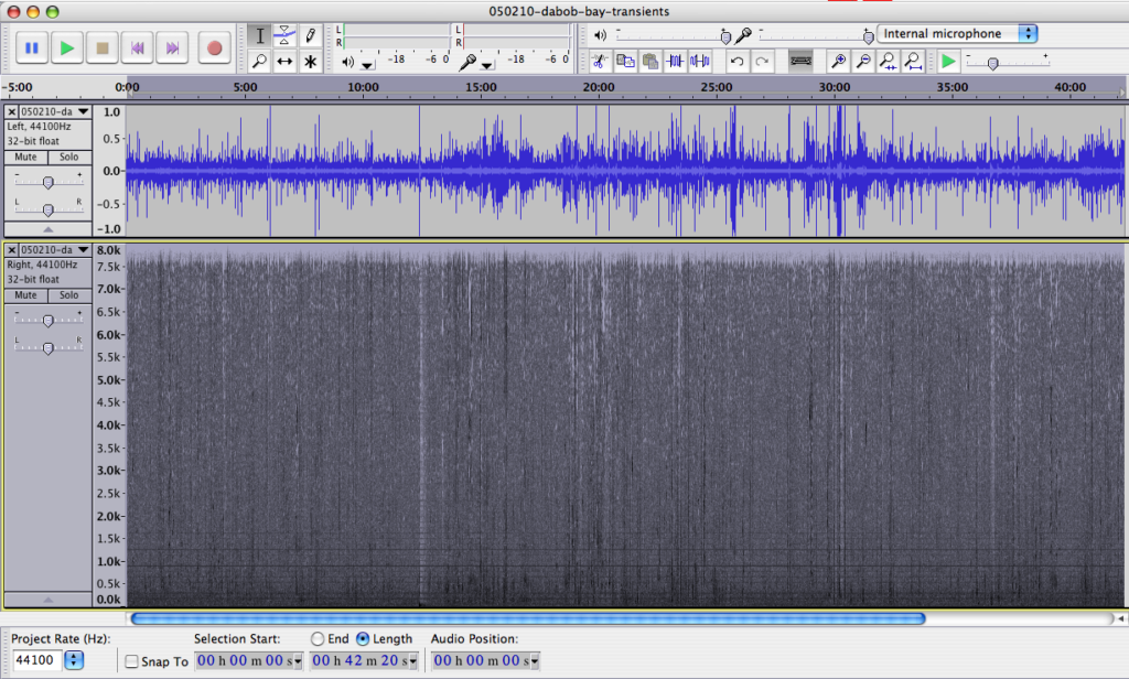
In a recent meeting led by Rear Admiral James Symonds (Commander, Navy Region Northwest), Shaari Unger of Naval Undersea Warfare Center (NUWC), Division Keyport, kindly handed out a CD with a great recording of transient orcas made in Dabob Bay (Hood Canal, WA) on February 10, 2005. She asked if any and all acoustic afficionados could listen to it and analyze it.
Here’s hoping our Northwest Navy neighbors are able to acquire and release additional recordings like this one that help us understand and enjoy the marine environment.
The CD jacket provides the following information:
The point of contact for the recording is NAVSEA, Keyport Public Affairs Officer, (360) 396-2699, kypt_pao@navy.mil
Start time: 10:45 (PST) 10 Feb 2005
End time: 11:27 (PST) 10 Feb 2005
Weather: Sunny and clear, unlimited visibility, light winds
Animals (data compiled by John Durban and Graeme Ellis): These are six killer whales, known to be part of the ‘west coast transient’ stock that ranges between the coastal waters of SE Alaska and California. These particular animals have been most frequently documented in SE AK and British Columbia. This group is comprised of two adult females [(T71 and T124A, both more than 20 years old), each with two offspring – one older offspring per femaile (T71A — 10 years, T124A1 — 9 years) and one younger offspring per female (T71B and T124A2, both around 5 years)]. These two ‘matrilines’ have not always been seen in association with each other.
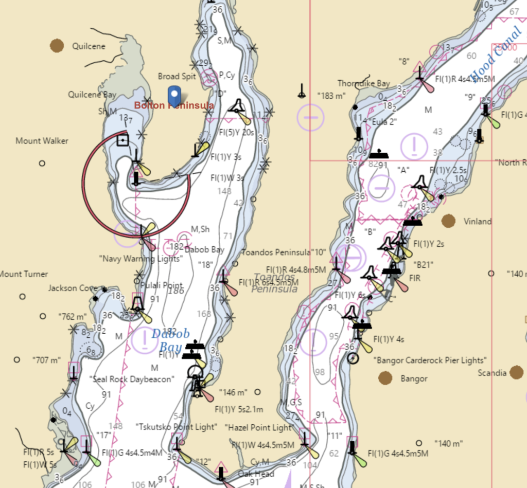
Visual observation during the recording: The animals were off Bolton Peninsula when first sighted. They were staying in one location moving back and forth over one area, which is considered feeding behavior. They then moved as a group from Whitney Point south, along the west side of Dabob Bay and continued south out of Dabob Bay.
As a standard operating procedure, the NAVSEA Keyport does not conduct active acoustic operations in the presence of whales at any NAVSEA Keyport test range. The Dabob Bay Range Site is staffed during normal working hours by NAVSEA Keyport. Our range operators are trained by NOAA to identify marine mammals.
NUWC maintains and operates the range on Dabob Bay where this recording was made. Their purpose is to test and evaluate undersea systems in support of research and development, and in support of maintenance and upgrade of existing systems. There were no operations scheduled the day this was recorded, and all scheduled testing activities were postponed for several days until the range was clear of the transient Orcas.


 Twitter
 LinkedIn
 Facebook